Wolf Creek Work Day
Live staking at the Wolf Creek Aquatic Organism Passage Project
Tue, Nov 29, 2022 10:00 AM (EST)
Wolf Creek Bridge,
Wolf Creek,
Tennessee
Questions?
Contact Event Host
Details
This event ended
Tue, Nov 29 - 12:00 PM
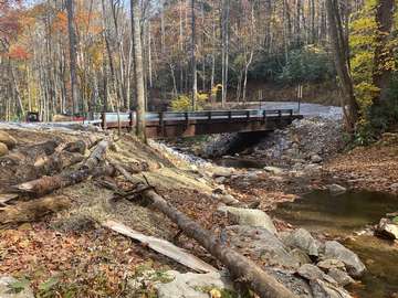
Come out and lend a hand for the final portion of the Wolf Creek Aquatic Organism Passage Project. A double corrugated metal pipe crossing was replaced with a channel-spanning bridge to enhance passage of native Brook Trout through the creek. Volunteers are needed to help install live stakes in key areas to promote bank stability and increase stream bank cover. We will be planting 800 - 1,000 live stakes that day. The project site is roughly 1 hour from Greeneville, TN and Asheville, NC, and 1 hour 20 minutes from Johnson City, TN.
We will meet on site (35.86243N, -82.92742W) at 10 am and we should be done by 3 pm.
Tools to install the stakes will be provided. Participants need to dress appropriately for the weather conditions and bring their own water. Waders are not required but might be useful to bring along. Lunch will be provided.
Directions from Johnson City, TN:
Take I-26E for approximately 22 miles to exit 43
At exit 43, turn left onto the short access road and then right at the stop sign for US-19W/TN-352
In 1 mile, stay right to stay on TN-352
In 5 miles, turn right to stay on TN-352
Stay on TN-352/NC-212 for 18.5 miles
Turn left onto NC-208 and follow for 3.5 miles, then turn right onto US-25.
Follow US-25 for 5 miles through the town of Hot Springs, NC. Towards the end of Hot Springs, turn right to stay on US-25N.
Continue on US-25N for 3 miles. Turn left onto Upper Shut-In Road.
Follow Upper Shut-In Road for approximately 6 miles. The road will turn to gravel as it heads steeply uphill. The Forest Service gate at the top will be open.
Directions from Asheville, NC:
Take I-26W 8 miles to exit 19A and merge onto US-25N/US-70W towards Marshall.
Continue for 21 miles and then turn left to stay on US-25N/US-70W.
Follow US-25 for 5 miles through the town of Hot Springs, NC. Towards the end of Hot Springs, turn right to stay on US-25N.
Continue on US-25N for 3 miles. Turn left onto Upper Shut-In Road.
Follow Upper Shut-In Road for approximately 6 miles. The road will turn to gravel as it heads steeply uphill. The Forest Service gate at the top will be open.
We will meet on site (35.86243N, -82.92742W) at 10 am and we should be done by 3 pm.
Tools to install the stakes will be provided. Participants need to dress appropriately for the weather conditions and bring their own water. Waders are not required but might be useful to bring along. Lunch will be provided.
Directions from Johnson City, TN:
Take I-26E for approximately 22 miles to exit 43
At exit 43, turn left onto the short access road and then right at the stop sign for US-19W/TN-352
In 1 mile, stay right to stay on TN-352
In 5 miles, turn right to stay on TN-352
Stay on TN-352/NC-212 for 18.5 miles
Turn left onto NC-208 and follow for 3.5 miles, then turn right onto US-25.
Follow US-25 for 5 miles through the town of Hot Springs, NC. Towards the end of Hot Springs, turn right to stay on US-25N.
Continue on US-25N for 3 miles. Turn left onto Upper Shut-In Road.
Follow Upper Shut-In Road for approximately 6 miles. The road will turn to gravel as it heads steeply uphill. The Forest Service gate at the top will be open.
Directions from Greeneville, TN:
Follow TN-107 south for 9 miles.
Take a slight right to stay on TN-107 as it leaves Asheville Highway. Continue for 8 miles.
At the stop sign, turn left onto US-25S/US-70E.
In 7 miles, turn right onto Upper Shut-In road.
Follow Upper Shut-In Road for approximately 6 miles. The road will turn to gravel as it heads steeply uphill. The Forest Service gate at the top will be open.
Directions from Asheville, NC:
Take I-26W 8 miles to exit 19A and merge onto US-25N/US-70W towards Marshall.
Continue for 21 miles and then turn left to stay on US-25N/US-70W.
Follow US-25 for 5 miles through the town of Hot Springs, NC. Towards the end of Hot Springs, turn right to stay on US-25N.
Continue on US-25N for 3 miles. Turn left onto Upper Shut-In Road.
Follow Upper Shut-In Road for approximately 6 miles. The road will turn to gravel as it heads steeply uphill. The Forest Service gate at the top will be open.
Loading...
Loading...
No fundraising information was found.
Loading...
Loading...
No performances assigned to this
track.
{{ performance.title }}
{{ performance.startDateDisp }} -
{{ performance.endDateHH }} {{ performance.endDateMM }} {{ performance.endDateAMPM }}
{{ performance.description }}