
Norwalk River Reach Assessments
Sign up for RIVERS App assessment "beats" on the Norwalk River
Free
Questions? Contact Event Host
{{calendarLabel}}
{{dow}}
{{calDate.dayOfMonth}}
Sold Out
Ended
{{calDate.available}}
This stream reach is from the Old Ridgefield Road to the NRVT trailhead at Merwin Meadows Park on Lovers Lane
This stream reach is from the NRVT Trailhead to School Road / RT 7 Overpass
This stream reach is from School Road / RT 7 to the bridge at the Wilton YMCA. Best parking access for this section is behind the Stamford Health office building at the corner of School Road and RT 7.
This stream reach is upstream from the Cannondale Train Station Bridge to the Bridge at Seeley Road.
This stream reach is from the bridge at Seeley Road to the bridge at Honey Hill Road
This stream reach is from Honey Hill Road to Old Mill Road. This section is best completed with two people - leave one car at Honey Hill and the second at the Old Mill Road Park and Fields.
This stream reach is from Old Mill Road bridge upstream to Redding Road - this is a longer section best completed by two volunteers. Leave one car at the Old Mill Road park and fields and another in West Redding.
This stream reach is upstream from the bridge at Sunset Pass Rd to Portland Ave (Train station)
This stream reach is upstream from the bridge at the train station on Portland Ave to Nod Hill Brewery.
This stream reach is from Nod Hill Brewery bridge upstream to the Days Inn in Ridgefield. This section is best completed by two volunteers - bring a buddy and park one car at Nod Hill and the other on the food truck pull off across the street from Days Inn.
This stream reach is upstream from the food truck pull off across the street from the Days Inn Ridgefield to Florida Hill Road.
This stream reach is upstream from the Topstone Rd Bridge to the RT 7 overpass by Litchfield Hill's Granite.
This stream reach is from Stonehenge Rd (just pass the Golf Performance Center Campus) to Great Pond Rd
Visit Fundraiser Page
{{ campaign.name }}
Visit fundraiser page to {{ campaign.ctaLabel.toLowerCase() }}
Visit Fundraiser Page
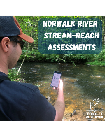
Help us look for deadbeat dams and identify habitat disturbances on the Norwalk River!
Sign up for a "beat" to walk and assess with Trout Unlimited's RIVERS App - an easy to use community science tool to record everything from old dams, riparian canopy degradation to sea lamprey spawning redds to help us collect important data and plan future restoration projects.
Before we split off and hit the river, we'll get started on how to download and use Trout Unlimited's RIVERS App, look at example disturbances and learn how to identify and record Sea Lamprey spawning redds that will be encountered.
Cart is empty
Tickets
Price
Qty